/foblogo.gif)
/redarrow10x4.gif)
/flag.gif) Contact Your Government! |
Mining in Barboursville: Uranium
At the August 29 DMME hearing, Friends of Barboursville presented several USGS and DMME studies that indicate the presence of elevated levels of uranium at the proposed mine site. The areas rich in uranium are strongly correlated with faults depicted on USGS maps. A map produced in 1981 by Leavy, Grosz and Johnson, based on this data, specifically identifies a uranium and thorium anomaly at the proposed mine site. Aerial radiometric data from flights over the Culpeper and Barboursville Basins shows an area of elevated uranium levels extending through Somerset and Barboursville, between Hardwick and Cowherd mountains. Uranium levels up to six times the regional average can be found in this area.
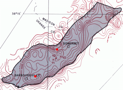
Aerial Radiometric Map by Leavy, Grosz and Johnson
Before the Virginia moratorium on uranium mining, 2,000 acres of land in Orange County was under lease to uranium mining companies. Local residents were approached by Marline Corporation with offers to buy mineral rights to their land.
In the current version of General Shale's state mining permit application, they say that there are no known uranium deposits in the Barboursville basin, and imply that it's never been investigated. This is incorrect. They seem to be confused because the name "Barboursville Basin" is a relatively recent term. (Some earlier studies refer to the area as the southern part of the Culpeper Basin.)
The map above represents only one of many investigations of the uranium in the Barboursville area. At least two aerial radiometric studies (a broad study of the Charlottesville quadrangle and a focused study of the Culpeper and Barboursville basins) were done in the early 1980s. Ground-level studies were also done, as part of the USGS Hydrogeochemical Stream Sediment Survey. These surveys clearly show elevated uranium levels in the Barboursville area.
For some reason, General Shale also says that there are no faults around the Barboursville basin. However, The USGS National Geochemical Atlas shows a fault line running directly through the proposed mine site.
The argument has been made that some of these uranium deposits are the result of radioactive components in fertilizer. Leavy, Grosz and Johnson note that this contributes to the noise in their data, but the text accompanying their map says "Most of the prominent high anomalies south of Herndon are in red-brown siltstone." [like the Balls Bluff Siltstone mined by General Shale] "These anomalies are characterized by tightly closed contours with steep gradients, especially in areas where fresh siltstone is exposed in quarries or pits...".
This strongly implies that underlying radioactive material is being exposed by mining. The association of the anomalies with "red-brown siltstone" might indicate that uranium was deposited when the sediment was laid down, as seems to have happened in the mudstone of the Newark Basin.
Finally, note that General Shale's existing Somerset mine is one of the high-count areas. To the best of our knowledge, General Shale does not fertilize its bricks.
Ultimately, the origin of the uranium is of no importance. The problem arises simply from its presence in the area.
General Shale plans to haul up to sixteen thousand dump truck loads per year across Blue Run. If the proposed mining operation transports Uranium-bearing material across the stream, the uranium levels in Blue Run would inevitably increase. The mining operation could also increase the levels of uranium in airborne dust. It might also increase levels in ground water, depending on the depth of General Shale's mining and the geometry of the local aquifers.
The EPA says that there is "no safe level of exposure" to radioactive materials, and that all such materials are classified as human carcinogens. EPA further says that exposure to such materials "has a potential to produce deleterious effects on human health, and that the magnitude of the effects are directly proportional to the exposure level."
In other words, increasing the levels of uranium in the environment would increase the risk of cancer. Exposure to even small quantities of uranium over long periods may also cause kidney disease, due to uranium's chemical toxicity. The proposed mine poses a significant threat to public health, especially for the children who would grow up in the homes and yards surrounding the proposed mine site. The increased risk of cancer and kidney disease for these families is not an acceptable price to pay for General Shale's convenience.
/nomine/brick.jpg)